Contents:
Never do I expect, always I hope
Dennis the Dachshund read by S.G.Hulme Beaman in Children’s Hour, 1930
This volume converts the 1988 edition of The History of St Peter & St Thomas, Stambourne to a much larger, possibly more tedious, compilation of all the data I have collected in the two decades of studying for it.
We purchased Tinkers in 1963. It is a Grade II listed XVIIc thatched cottage in Wesley End and is the most northerly messuage in the village. Its age and the impressive Norman Tower of the church stimulated our interest in the history of the village from the outset. Some two decades later I became church warden and found that the existing pamphlet needed revision. Recently we moved to Clare and found a remarkable number of connections between the two places and the intervening village of Stoke by Clare. All three find numerous mentions in this text so it should be made clear that where prepositions such as here and possessive pronouns are used they apply to Stambourne itself.
Apart from minor additions, such as the appointment of Rector and Rural Dean John Martin Suddards since that date, the earlier copy remains an accurate handbook guide to the church and village: the Parochial Church Council has recently reprinted it.
Many of the data herein come from the work of others which they have kindly sent me. General acknowledgements appear at the end. Specifically, much of the early analysis and text were the work of Nicholas Enticknap, in particular the transcription and translation of the parish registers from 1559 to 1811, taking a year of his spare time. He wrote the following two paragraphs then.
The visitor to Stambourne today finds a peaceful rural village, inhabited mainly by agricultural workers and by refugees from the pressures of London life. Lacking the chocolate box appeal of villages such as neighbouring Finchingfield, it nonetheless has an unobtrusive charm of its own. That charm derives, perhaps, from the sense of remoteness. The nearest towns are both ten miles away Braintree to the south, Sudbury to the east and Stambourne lies off the major highways and through routes. It has never had a railway station the nearest one was Birdbrook, two miles to the northwest on the Colchester to Cambridge line. This line was closed in 1961, leaving Braintree as the nearest station. Until 1986 Stambourne was accessible by bus from London, but now the nearest stopping point is three miles away in Finchingfield.
So Stambourne is probably as secluded a village as you can find within 50 miles of London. Look around over the flat East Anglian countryside and you will see in all directions vistas composed mainly of farmland, broken by the occasional copse and dotted around the skyline, neighbouring villages such as Toppesfield and Great Yeldham. The sense of seclusion must have been greater in times gone by, before the arrival of the motor car. It takes no great imagination to picture the villagers of bygone centuries toiling patiently away at their daily tasks, with little time for the major political and religious issues of their day. None the less the village and in particular the parish church bear mute witness to many of those issues and events.
The decade that has elapsed since the above was written has made little difference to its validity. This new text is better described as an Historical Directory than as a guide book and its main purpose is to record the many sets of information since elucidated, discovered and analysed. Perhaps I may be allowed some speculation too; I have tried clearly to differentiate it from the attested facts.
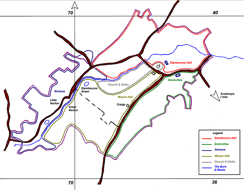
A freehand map of the outlines of the Four Estates owning land in Stambourne
This shews the shape of the roughly rectangular village & the burn that passes through it from northeast to southwest. The probable areas of the three legally constituted manors and the deduced outline of a fourth division which mainly belonged to the de Stanburn family, latterly calling themselves Gentlemen of Stambourne are outlined.
The burn itself is not named on any map I have seen. The name of the village derived from two large flat stepping stones in it at its nearest point to the church.
The white area to the West and South of the church is the glebe.
2½” = 1 mile. Ex OS 1919 – 1954
A rough rectangle 2 miles by 1¼ = 2½ sq. miles with a prolongation towards Finchingfield of ¾ sq. mile = a total area of approximately 3 square miles.